

Cyber Insurance Claims Face Greater Scrutiny as Underwriting Tightens
Cyber insurers are tightening underwriting standards, increasing scrutiny of security controls, and reevaluating coverage as ransomware losses, AI risks, and geopolitical threats drive concerns about systemic cyber events.
June 8
Insurance Industry
Liability
Litigation
Risk Management
Technology

Tennessee Interstate Closed After Fireworks Cargo Ignites on I-75
A trailer carrying fireworks caught fire on Interstate 75 in Hamilton County, Tennessee, forcing highway closures as explosives launched across multiple lanes of traffic. No injuries were reported, but the incident highlights transportation and cargo-related insurance risks.
June 8
Auto
Liability
Property
Risk Management
Subrogation
Tennessee

Project Jetsetter Exposes International Auto Insurance Fraud Network in Canada
A multi-year investigation uncovered organized criminal groups linked to staged collisions, vehicle financing fraud, and false insurance claims that generated millions in losses and drove up costs for insurers and policyholders.
June 8
Auto
Fraud
Insurance Industry
Legislation & Regulation
Technology

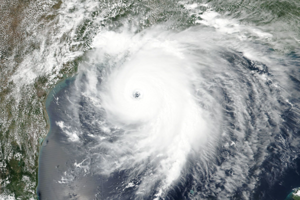
Tropical Storm Boris Threatens Flooding and Mudslides Along Southern Mexico Coast
Heavy rainfall from Tropical Storm Boris could trigger flooding and mudslides across Guerrero and Oaxaca. Insurers and catastrophe response teams are watching for potential property and infrastructure losses as the storm approaches landfall.
June 8
Catastrophe
Property
Risk Management

NICB Warns Contractor Fraud Is Rising Nationwide After Natural Disasters
As communities recover from tornadoes, floods, wildfires, and other disasters, NICB says contractor fraud schemes are becoming more sophisticated, with roofing scams, inflated mitigation claims, and assignment of benefits abuse among the most common threats.
June 8
Catastrophe
Fraud
Insurance Industry
Property
Risk Management

Meta Fraud Exposure Raises New Liability Questions for Insurers
New fraud data from Lloyds Bank and recent U.S. court rulings are increasing scrutiny of Meta's role in online scams, creating new questions about liability, insurance coverage, cyber risk, and potential subrogation opportunities.
June 8
Fraud
Insurance Industry
Legislation & Regulation
Litigation
Risk Management

FICO: Insurers Must Shift From Reactive Fraud Detection to Connected Intelligence
New FICO report argues that fragmented data systems are leaving insurers vulnerable to organized fraud networks and calls for real-time, enterprise-wide fraud intelligence.
June 8
Fraud
Insurance Industry
Technology

Texas Police Chief’s Staged Vehicle Theft Insurance Fraud Conviction Upheld on Appeal
A federal appeals court found sufficient evidence that a Texas police chief conspired to burn his wife's SUV, report it stolen, and collect insurance proceeds. The case highlights multiple fraud indicators that claims investigators identified before any confession emerged.
June 5
Auto
Fraud
Insurance Industry
Litigation
Risk Management
Texas

Northern California Earthquakes Highlight California’s 87% Earthquake Insurance Gap
Five earthquakes off the Northern California coast caused little damage, but they renewed attention on the fact that most California homeowners lack earthquake insurance and would receive no coverage for quake-related property losses.
June 5
Catastrophe
Insurance Industry
Risk Management
Underwriting

Amazon Sued Over Ring Facial Recognition Feature in Proposed Class Action
A proposed class action alleges Ring's Familiar Faces feature collected and stored facial recognition data from individuals without their consent, raising privacy and liability concerns for AI-powered security systems.
June 5
Insurance Industry
Liability
Litigation
Risk Management
Technology
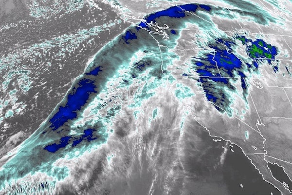
Potential Tropical Depression Could Form in Gulf by Mid-June
Forecasters are monitoring a potential tropical depression that could develop in the Gulf by mid-June. Even if a named storm does not form, increased rainfall and tropical moisture could affect Florida and other Gulf Coast areas.
June 5
Catastrophe
Property
Risk Management
Florida

Insurance Fraud Detection Market Tops $20B as Insurers Expand AI Tools
Insurers are expanding their use of AI, telematics, digital identity verification, and predictive analytics as fraud schemes become more complex and costly across multiple lines of business.
June 5
Auto
Fraud
Insurance Industry
Property
Risk Management

Convr Report Highlights AI Strategy Gap Among Commercial Insurance Carriers
Commercial insurance carriers are rapidly deploying AI underwriting tools, but many leaders lack confidence in the strategic framework needed to maximize those investments and deliver measurable business outcomes.
June 3
Education & Training
Insurance Industry
Technology
Underwriting

Natural Disaster Insurance Gap Tops $424B as Cat Losses Rise
Swiss Re says uninsured catastrophe losses rose 7% last year, with North America facing the largest gap as exposed property values climb.
June 3
Catastrophe
Insurance Industry
Property
Risk Management
Underwriting
NHC Tracks First Eastern Pacific Tropical Disturbance of 2026 Hurricane Season
The system has a 60% chance of development within seven days, while NOAA forecasts an above-normal Eastern Pacific hurricane season.
May 29
Catastrophe
Insurance Industry
Marine
Property
Risk Management
California


